|
|
AW Geographical Atlas Image
|
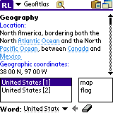
AW Geographical Atlas 3.0 Screenshot
802.11 B Palm, 802.11 Palm, Atlas, City, Country, Flag, Little Palm, Map, Palm, Palm 4.0, Palm 802.11, Palm 802.11 B, Palm Atlas, Palm Geography, Palm Gis, Palm Os, Palm Os 4.1 Software, Palm Os v3 5
Carry the atlas everywhere! Detailed information about countries including location, neighbours, population, economy and military. See the map and flag of each contry of the World. Maps display country borders, neighbours, major cities and rivers.
|
|
AW Geographical Atlas Also Mentioned
|
| Atlas Timesheet Software 8.415 |
 |
| Real power comes from ATLAS Timesheet Software. Use it to streamline the entry, tracking, billing, and reporting of time and expense information throughout your organization. |
| WinSuperKit 6.2.2 |
 |
| WinSuperKit is a powerful network, file compare toolkit that helps you to get ip address and geographical location, capture network packet, monitor network speed. |
| Chartbook Maker 1.2.0 |
 |
| Easily print full resolution marine charts in a handy booklet format using normal printer!
Great for small boats and quick reference without unrolling a large chart.
Print as many copies as you... |
| MileCharter 2.12 |
 |
| Calculate Mileage Charts and Tables with Microsoft MapPoint. Calc. tables for customers and suppliers incl. "closest only", or to create "road atlas" tables. Output Distances, travel times and/or... |
| Ip2CountryResolver 1.2 |
 |
| If you are doing business on the Internet and you want to know where your users are from, you've found the right place! Ip2CountryResolver will help you to identify visitor's geographical location... |
| Atlas java Utiities 1.3 |
|
| Java utilities for browse and edit web apps. Display/process HTML forms to view and edit objects, search and list objects. Manage request context. Time display and conversion. Factors standard... |
| GPS-Action 1.2 |
 |
| Depending on your geographical location GPS-Action will fire alarm, open the application, change profile, launch the website, open a document or a certain application for you.All actions are... |
| IP-Country mapping Database 1.02 |
|
| IP-Country mapping Database - Geo-targeting IP Address to Country.IP-Country mapping Database can help you identify visitor geographical location ie. country,region, city and ISP, using a ip... |
| Panorado Flyer 1.2 |
 |
| Panorado Flyer is a simple geocoding tool for linking JPEG image files to the location where the picture was taken, using geographical coordinates. It can be lauched from the Windows Explorer's... |
| Geodaten German Admin (Deutsch) 11.10 |
 |
| Geodata of the Federal Republic Germany with municipalities, postal codes, telephone preselections. Georeferences as Gauss Krueger- UTM-, Geographic Coordinates and Ground Elevations. For branch... |
|
|
|